The Bluff sits forms part of the divide between the Howqua and the Upper Goulburn Rivers, almost immediately south of Mt Buller. Cut on the north side by a series of cliffs, and sloping off gently towards southern valleys, this is a charismatic mountain. Its far western ridge, where the storms push in after making a big rise from the surrounding valley, is like the prow on a great uplift of rock and earth – in summer it feels like it splits the incoming weather, fuelling lightening storms and bringing rain and great updrafts of wind.
The mountain is a big, humped-back ridgeline of old, upraised sea bed, which stretches eastwards, back into snowgum forest, towards Mt Howitt, itself at the centre of a giant wheel of river systems. It can be icy and very windy up on the summit and feel like such an alpine place as you gaze down at lowland forests almost a kilometre below. When it gets a bit nasty on the summit, you have to go with the wind and drop down eastwards, further along its exposed ridge, into the trees around the Blowhole to get out of the weather.
To the south, the reddish rocky slopes of Mount McDonald sit over the deep open space of the Upper Goulburn River. If you walk eastwards past Mt Eadley Stoney, you find yourself in four wheel drive country, with seemingly endless numbers of people ripping and scraping their way along a snake back ridge towards Mt Lovick. But these folk never seem to wander far from their trucks, so its easy to escape from trail bike and 4WD country – just slip away through the trees a little way and find a glade or a shady spot to camp.
Northwards, across the clear void of sky over the Howqua, lies the Mt Buller ridge, with its winter lights and ski tows.
And westwards are the scrappy, rocky summits of Rocky Ridge and Eagles Peaks.
From late spring through summer you get an amazing show of colour, when the snow daisys are in full bloom and the breeze comes warm and gentle off the ridges and valleys far below.
A quick report from a trip to The Bluff. An autumn visit

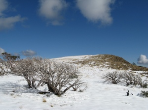
autumn snow near the summit of The Bluff, May 2009
fire impacts
Recent fires have had a considerable impact on the mountain. The 2006/07 fires burnt up from the Howqua River, burning very hot as it raced up to Bluff Hut. The hut was destroyed (and subsequently re-built) and the mature trees in the surrounding snow gum forests were largely destroyed. There is now thick regrowth on this part of the mountain.
Further west towards the summit, the fire burnt more slowly up from Refrigerator Gap onto the northern slopes of the mountain below the cliffs. Remarkably, most of the mature trees here (including alpine ash) survived.
Spring floods in late 2010 also had a big impact on some streams flowing off the mountain, with massive wash-outs and movement of rocks and logs.
camping
Apart from hunkering down amongst the patches of snow gum on the summit, there are two obvious, more sheltered sites.
One option is in the forest immediately south of the Blowhole, about half way between the summit and Bluff hut. Once you reach the Blowhole, just walk down into the trees for sheltered camping amongst the snowgums. Like the rest of the southern side of the mountain, these snowgums were badly hit by recent fires. However, one small pocket was not torced, just at the treeline where you enter the forest. The re growth here makes for a slightly less pleasant camp than had been the case previously, but possibly the snow grass will start to dominate again as the canopy thickens up. There is sometimes water available in the little stream that starts here and runs next to the forest and down into the Upper Goulburn valley.
There is also good sheltered camping in the little valley directly south of the summit, where a shallow trickle of a stream slides out of the mountain, admidst succulent flowers and alpine scrub. A snow drift on the sheltered southern slopes above the campsite often lasts well into the summer.
access
Access is via a good dirt road from just near Merrijig, the Howqua track, and then Brocks Road. You will need a map.
There are two ways in. The harder option is to walk from the carpark on the road above Refrigerator Gap (this is well sign posted). The track heads uphill through forest before reaching the escarpment, where it steepens considerably and there are a few scrambles through the rock belts. This is an incredible forest of old snow gum, tussock grass and shrubs, with un folding views towards Rocky Ridge, Eagles Peaks and beyond. As you reach the treeline the track eases off for the final few hundred metres to the summit.
The easier option is to drive all the way up to Bluff hut. The last 3 km require a 4WD because of the culverts on the road, however, it is a straight forward drive, especially in dry weather. Park near the hut and follow the trail heading westwards up through the belt of burnt-out snowgums before emerging on the southern slopes of Mt Eadley Stoney. Follow the trail past the obvious gap (The Blowhole) and then climb up onto the summit.


